
Road & Geosite Conditions
Fully Accessible
- Number
- Area
- 1. Ichiburi Geosite
- 2. Oyashirazu Geosite
- 3. Omi Coast Geosite
- 4. Omigawa Jade Gorge Geosite
- 5. Imai Geosite
- 6. Itoigawa-Shizuoka Tectonic Line and Salt Trail(North) Geosite
- 7. Maikomidaira Geosite
- 8. Hashidate Gold Mine Geosite
- 9. Kotakigawa Jade Gorge Geosite
- 10. Tsugami Shindo Geosite
- 11. Himekawa Gorge Via Oito Line Geosite
- 12. Itoigawa-Shizuoka Tectonic Line and Salt Trail(South) Geosite
- 13. Himekawa Gorge Geosite
- 14. Renge Geosite
- 15. Itoigawa Coast Geosite
- 16. Miyama Park and Museums Geosite
- 17. Tsukimizunoike Geosite
- 18. Umidani Gorge Geosite
- 19. Amakazariyama Geosite
- 20. Yakeyama Geosite
- 21. Benten-iwa Geosite
- 22. Shindosan Geosite
- 23. Gongendake Geosite
- 24. Tsutsuishi Hamatokuai Geosite
- Jade
- 1. Ichiburi Geosite
- 2. Oyashirazu Geosite
- 3. Omi Coast Geosite
- 4. Omigawa Jade Gorge Geosite
- 9. Kotakigawa Jade Gorge Geosite
- 15. Itoigawa Coast Geosite
- 16. Miyama Park and Museums Geosite
- Fossa Magna
- 5. Imai Geosite
- Itoigawa-Shizuoka Tectonic Line and Salt Trail(North) Geosite
- 11. Himekawa Gorge Via Oito Line Geosite
- 12. Itoigawa-Shizuoka Tectonic Line and Salt Trail(South) Geosite
- 13. Himekawa Gorge Geosite
- 17. Tsukimizunoike Geosite
- 21. Benten-iwa Geosite
- 22. Shindosan Geosite
- 24. Tsutsuishi Hamatokuai Geosite
- Mountainous areas
- 7. Maikomidaira Geosite
- 8. Hashidate Gold Mine Geosite
- 10. Tsugami Shindo
- 14. Renge Geosite
- 18. Umidani Gorge Geosite
- 19. Amakazariyama Geosite
- 20. Yakeyama Geosite
- 23. Gongendake Geosite
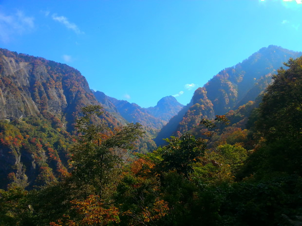
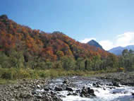
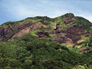
Umidani Gorge, rather unassuming in its appearance, was created when a volcano was bisected by a river. This volcano formed over 3 million years ago, when the Fossa Magna region was submerged under the sea. The resulting cliff walls beautifully preserve the internal features of this former volcano, including volcanic ash and lava flows. From the viewing platform, you can see a strangely-shaped rock called "Zenmai Jizo" for its resemblance to the zenmai mountain vegetable as well as that to a jizo Buddhist statue. This rock formation is said to watch over and protect those who travel through this gorge.
In the upstream region of the Umikawa River, there are absolutely no erosion control structures in place, leaving this as one of the few examples in Japan of a river valley in its natural state. Umidani Highland, a large dried river bed, was formed when a large landslide in 1597 dammed the river, creating a temporary lake. With colors that change from light green in spring to deep green in summer and beautiful reds in autumn, this gorge is a hiker's paradise.
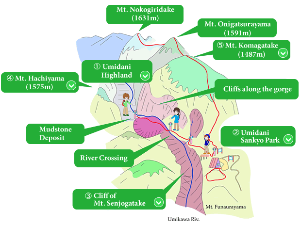
 Umidani Highland
An area of exquisite beauty, the Umidani Highland is wide valley high upstream along the Umikawa River. This section, much wider than the rest of the gorge, was created when a landslide temporarily dammed the river, forming a temporary lake which eroded the mountainsides around it.
The landscape here, with a clear mountain stream flowing through a wide gorge between tall mountains, has often been compared favorably to the Kamikochi Highlands in neighboring Nagano Prefecture.
※Note: The Umikawa River is prone to flooding. Do not attempt to hike through the gorge in inclement weather.
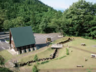
 Umidani Sankyo Park
Umidani Sankyo Park is the basecamp for those looking to hike into the Umidani Gorge or the various mountains in this area, especially Mt. Komagatake.
With ample parking, wide lawns, tent sites, a barbecue shelter, and fresh spring water, this park is a great place to spend a night enjoying the beauty of Japan's mountains.
An observation deck at the park offers a breathtaking view of the gorge.
 Cliff of Mt. Senjogatake
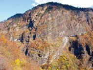
This massive wall-like cliff located across the gorge from the observation deck is inner face of Mt. Senjogatake. If you look carefully at the rock face, you will see a number of diagonal stripes along its surface. The stripes were formed over the ages by layers of lava and ash flowing from the submarine volcano that formed this mountain. Repeated eruption cycles caused these lava and ash layers to stack to 1600m in height. The volcano was then pushed above the sea and split into two by the Umikawa River, forming the impressive rock cliff visible today.
 Mt. Hachiyama
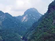
Mt. Hachiyama's name means "clay pot mountain," in reference to its rounded, protruding peak which looks like a clay pot turned upside down.
This mountain formed underground when magma flowed through here collecting and cooling into a porphyrite mass. This porphyrite was much stronger than the mudstone and sediment which once covered the area, so when the mudstone eroded away, all that remained was Hachiyama.
 Mt. Komagatake
At a height of 1487m, impressive Mt. Komagatake was formed as a result of submarine volcanic eruptions. As part of the Umidani Mountains, the ridge from its peak passes over Mt. Onigatsurayama and Mt. Nokogiridake, finally ending with beautiful Mt. Amakazariyama.
A trail climbing Mt. Komagatake begins at Umidani Sankyo Park.
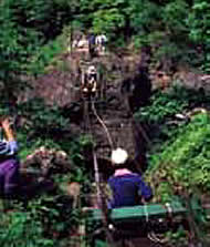
Kurikoshi Basket Bridge
Along the trail to the Umidani Highlands is Kurikoshi, the name given to the point where the trail crosses the Umikawa River. There used to be a kago-watashi or basket bridge here. Hikers would climb into a basket supported by ropes and pulleys and pull themselves across. Such kago-watashi were once fairly common in remote mountain regions of Japan.
Unfortunately, the kago-watashi was destroyed in a flood in 1995, so now the river must be waded across on foot.
Hiking in Umidani Gorge
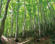
A swath of beech trees cuts across the base of Mt. Komagatake. These trees and the soil they live in form a sort of green dam which allows water to collect throughout this region, nourishing the plants and animals which call the Umidani Gorge home and providing exquisite hiking scenery for those who make the trek.
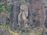
Zenmai Jizo
On the face of Mt. Senjogatake is Zenmai Jizo. A natural rock formation, from a distance it looks a lot like a jizo Buddhist statue. It's said to keep a silent vigil over the gorge, looking after the people who travel through it.
Route to Umidani Gorge Geosite
Destination: