
Road & Geosite Conditions
Fully Accessible
- Number
- Area
- 1. Ichiburi Geosite
- 2. Oyashirazu Geosite
- 3. Omi Coast Geosite
- 4. Omigawa Jade Gorge Geosite
- 5. Imai Geosite
- 6. Itoigawa-Shizuoka Tectonic Line and Salt Trail(North) Geosite
- 7. Maikomidaira Geosite
- 8. Hashidate Gold Mine Geosite
- 9. Kotakigawa Jade Gorge Geosite
- 10. Tsugami Shindo Geosite
- 11. Himekawa Gorge Via Oito Line Geosite
- 12. Itoigawa-Shizuoka Tectonic Line and Salt Trail(South) Geosite
- 13. Himekawa Gorge Geosite
- 14. Renge Geosite
- 15. Itoigawa Coast Geosite
- 16. Miyama Park and Museums Geosite
- 17. Tsukimizunoike Geosite
- 18. Umidani Gorge Geosite
- 19. Amakazariyama Geosite
- 20. Yakeyama Geosite
- 21. Benten-iwa Geosite
- 22. Shindosan Geosite
- 23. Gongendake Geosite
- 24. Tsutsuishi Hamatokuai Geosite
- Jade
- 1. Ichiburi Geosite
- 2. Oyashirazu Geosite
- 3. Omi Coast Geosite
- 4. Omigawa Jade Gorge Geosite
- 9. Kotakigawa Jade Gorge Geosite
- 15. Itoigawa Coast Geosite
- 16. Miyama Park and Museums Geosite
- Fossa Magna
- 5. Imai Geosite
- Itoigawa-Shizuoka Tectonic Line and Salt Trail(North) Geosite
- 11. Himekawa Gorge Via Oito Line Geosite
- 12. Itoigawa-Shizuoka Tectonic Line and Salt Trail(South) Geosite
- 13. Himekawa Gorge Geosite
- 17. Tsukimizunoike Geosite
- 21. Benten-iwa Geosite
- 22. Shindosan Geosite
- 24. Tsutsuishi Hamatokuai Geosite
- Mountainous areas
- 7. Maikomidaira Geosite
- 8. Hashidate Gold Mine Geosite
- 10. Tsugami Shindo
- 14. Renge Geosite
- 18. Umidani Gorge Geosite
- 19. Amakazariyama Geosite
- 20. Yakeyama Geosite
- 23. Gongendake Geosite
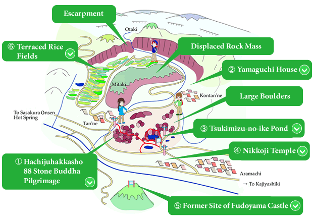
Tsukimizu-no-ike Pond, well-known for its wisteria flowers, is located at the end of a massive landslide. The uppermost part of this landslide forms Otaki waterfall, and is part of a slip plane produced about 3 million years ago by volcanic activity. This volcanic breccia lies on top of soft, weakly indurate mudstone that had collected on the bed of the Fossa Magna Sea. When the mountains began to rise in this area, the mudstone slowly began to slip, bringing the breccia down with it. The mountain found behind Kontanne Village was formed when one of these massive chunks of land broke apart from the ridge and slid down. Deeper in the valley is a large mass of boulders which broke off from this landmass. With many boulders up to tens of meters in height accumulated in one area, this valley produces a truly unusual landscape in contrast with the rest of the valley.
Tsukimizu-no-ike and Hosoike Ponds are fed by springs seeping up from underneath the landslides and boulders. In ages past, the springs here provided water for nearby villages. Today, the areas of slipped land and mudstone provide an ideal place for rice cultivation and the springs at the lower end of the slope are used for cultivating wasabi. The idyllic scenery of terraced rice fields along the slopes of the landslide is not to be missed.
Throughout this mysterious scene of boulders and springs, a Hachiju-Hakkasho, or collection of 88 stone images of Buddha, was constructed toward the end of the Edo period. A pilgrimage through this holy site is certain to prove a profound experience for any visitor.
The Tsukimizu-no-ike Geosite is a beautiful region where you can see how the geology of the Fossa Magna has shaped the lives of the people living within it.

 88 Stone Buddha Pilgrimage
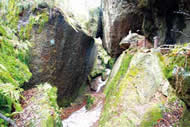
During the 1800s a Buddhist priest named Gyokuzui lived in one of the villages that would later become part of Itoigawa City. He became famous for his prolific statue carving, having in his life carved literally hundreds of stone Buddhist statues.
One of the most famous but also most difficult pilgrimages for Japanese people has been the 88 Temple Pilgrimage in Shikoku. However, during Gyokuzui's life Shikoku was very far and the trip was too expensive and too difficult for most. Wanting the people of the Itoigawa region to be able to make the pilgrimage more easily, he placed 88 stone statues of the Buddha among the boulders here near Tsukimizu-no-ike Pond. The entire pilgrimage takes about two hours to make and features beautifully rugged landscape created by the massive landslide which shaped this geosite.
 The Yamaguchi House - A Historic Snow Country Residence
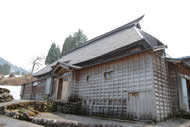
This house, owned by the Yamaguchi family, was originally built in 1779 as the home of the local village head. The roof was originally thatched, but has since been replaced with steel.
It's an excellent example of traditional Japanese "snow country" architecture. The frame is very sturdy and the roof is very highly sloped in order to cope with very heavy snowfall. In addition, the floor is raised about 90cm from the ground. The Yamaguchi family still lives in this house, so it is not open to the general public.
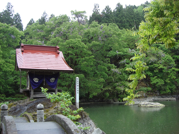
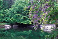
 Tsukimizu-no-ike Pond
Tsukimizu-no-ike Pond is a very small pond which was formed when a massive landslide dammed up flow from a natural spring. The water level varies dramatically throughout the year, dropping very low in summer and autumn and overflowing in spring. The water from the spring's source is incredibly clean and is used by the local community not only for agriculture, but for drinking water.
Around the pond are extremely massive boulders carried down by landslides. Together with the pond, these boulders make a naturally formed Japanese-style rock garden.
The forest around the garden abounds with wild wisteria which bloom to the delight of visitors every May.
 Nikkoji Temple
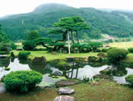
Believed to have been first established in 748, this temple features a small but beautiful Japanese garden which is located atop a hill with Mt. Fudoyama, Mt. Hokogatake, and the Hayakawa River Valley to its back. The Japanese White Pine tree in the center of the garden is estimated to be over 700 years old .
The temple also hosts a festival every April called the "Nikkoji Kenka Matsuri." This festival involves two large groups of men who lift heavy shrines and ram them together. It is a very old festival and, held together with neighboring Hakusan Shrine, it is one of the rare remaining examples of Buddhist and Shinto comingling, a practice that was very common in Japan until it was suppressed in the early 20th century.
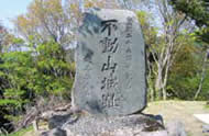
 Fudoyama Castle
During the Warring States Period, which was a period of constant civil war that lasted from the 15th century until the 17th century, Mt. Fudoyama was the site of Fudoyama Castle. The Uesugi family, which ruled Echigo Province (now the mainland part of Niigata Prefecture), had this castle constructed as a satellite castle, one of many built along the province's western border.
The castle has long since been destroyed, but a few remnants including moat ditches and wells remain. The view from what was once the castle keep offers an excellent panorama of the Hayakawa River Valley.
 Terraced Rice Fields
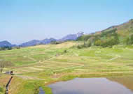
The landslides that created Tsukimizu-no-ike also produced long gently sloping terrain , near the villages of Kontanne, Tanne, and Mitaki. The people of these villages have over the generations carved these slopes into a series of terraced rice fields.
Using the sloping terrain and natural springs in this way is only one example of the way the people of the geopark take advantage of the geology of the land.
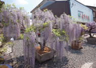
Japanese Wisteria "Fuji"
The area around Tsukimizu-no-ike Pond is abundant with wild wisteria. The people living here have grown quite fond of these wisteria plants and so many people in the town and villages around this site grow their own.
Every May the town of Aramachi, located along the approach to Tsukimizu-no-ike Pond, becomes a dazzling "Wisteria Road" as community members display their prized plants for the annual Wisteria Festival.
Route to Tsukimizunoike Geosite
Destination: