
Road & Geosite Conditions
Fully Accessible
- Number
- Area
- 1. Ichiburi Geosite
- 2. Oyashirazu Geosite
- 3. Omi Coast Geosite
- 4. Omigawa Jade Gorge Geosite
- 5. Imai Geosite
- 6. Itoigawa-Shizuoka Tectonic Line and Salt Trail(North) Geosite
- 7. Maikomidaira Geosite
- 8. Hashidate Gold Mine Geosite
- 9. Kotakigawa Jade Gorge Geosite
- 10. Tsugami Shindo Geosite
- 11. Himekawa Gorge Via Oito Line Geosite
- 12. Itoigawa-Shizuoka Tectonic Line and Salt Trail(South) Geosite
- 13. Himekawa Gorge Geosite
- 14. Renge Geosite
- 15. Itoigawa Coast Geosite
- 16. Miyama Park and Museums Geosite
- 17. Tsukimizunoike Geosite
- 18. Umidani Gorge Geosite
- 19. Amakazariyama Geosite
- 20. Yakeyama Geosite
- 21. Benten-iwa Geosite
- 22. Shindosan Geosite
- 23. Gongendake Geosite
- 24. Tsutsuishi Hamatokuai Geosite
- Jade
- 1. Ichiburi Geosite
- 2. Oyashirazu Geosite
- 3. Omi Coast Geosite
- 4. Omigawa Jade Gorge Geosite
- 9. Kotakigawa Jade Gorge Geosite
- 15. Itoigawa Coast Geosite
- 16. Miyama Park and Museums Geosite
- Fossa Magna
- 5. Imai Geosite
- Itoigawa-Shizuoka Tectonic Line and Salt Trail(North) Geosite
- 11. Himekawa Gorge Via Oito Line Geosite
- 12. Itoigawa-Shizuoka Tectonic Line and Salt Trail(South) Geosite
- 13. Himekawa Gorge Geosite
- 17. Tsukimizunoike Geosite
- 21. Benten-iwa Geosite
- 22. Shindosan Geosite
- 24. Tsutsuishi Hamatokuai Geosite
- Mountainous areas
- 7. Maikomidaira Geosite
- 8. Hashidate Gold Mine Geosite
- 10. Tsugami Shindo
- 14. Renge Geosite
- 18. Umidani Gorge Geosite
- 19. Amakazariyama Geosite
- 20. Yakeyama Geosite
- 23. Gongendake Geosite
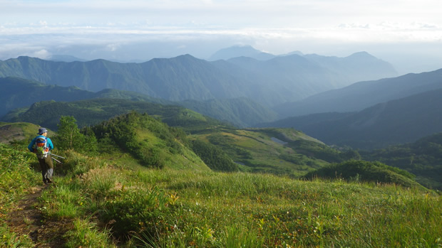
Connecting the Sea of Japan to the Northern Alps, rising in elevation from 0 to 3,000 meters over the course of 27km, Tsugami Shindo is a truly unique trail. Devoting 10 years to its construction, the locally-based "Sawagani Mountaineering Club" finished construction of this trail in 1971. This trail's value lies not only in its beauty, but also in its use as an excellent learning tool. The mountain trail passes through many different kinds of strata including Cenozoic intrusive rock, Mesozoic strata, and Paleozoic metamorphic rock and serpentinite. Mt. Kikuishiyama is home to a wealth of fossils including Jurassic ammonite and ferns. Along the Tsugami Shindou you can enjoy a variety of geological changes and mountain forms.
Along the trail grow many varieties of alpine flora, from low mountain, mountain recess, subalpine, and alpine plants. There are also many alpine plants in the area that have thrived since the glacial period.
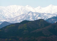
At 27km in length it takes about three days and two nights to traverse the entire length of the trail. For this reason there are three lodges, Shiratori Lodge, Tsugami Mountain Retreat, and Asahi Lodge, located at key points along the way. From atop the mountains of this trail you can see the Noto Peninsula, stretching like an arm out into the sea, while all around you spread the Northern Alps, making the view from this trail one visitors will never forget.
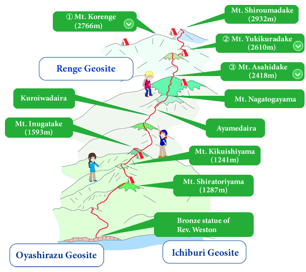
 Mt. Korenge
Formed out of granite, at 2766 meters Mt. Korenge is the tallest peak in Niigata Prefecture, located on the border with Nagano Prefecture. The mountain actually lost 3 meters to its height in recent years when the very peak of the mountain collapsed, forming a second ridge on the Nagano side. On the eastern side of the mountain is Hakuba-Ōike Pond, which was formed by lava flow off nearby Mt. Norikuradake Due to its height, it is home to a variety of alpine plants. It is also one of the few homes in Japan of the rock ptarmigan, known in Japan as the raichō, or thunderbird. While a game bird in many other countries, the thunderbird is a beloved protected species in Japan.
 Mt. Yukikuradake

Mt. Yukukuradake sits between Mt. Shiroumadake and Mt. Asahidake. Its peak is formed out of crystalline schist. Silver was mined from this mountain long ago at the Renge Mine, remains of which are still visible today. One of the mountain climbing trails in this area passes by the old site of the mine's office building and foundries.
During the summer this mountain is a popular destination for climbers, while in early spring it attracts back country skiers.
 Mt. Asahidake
This mountain, with its dome-shaped peak, is subject to heavy wind on its western side, which has over time produced gently rolling slopes. The eastern side of the mountain is densely covered in dwarf pines. The peak of the mountain is made up of sedimentary stone, while a large section of the northeast side is serpentinite.
On the east side of the mountain, a number of rare alpine flowers can be seen growing among the serpentinite along the climbing trail.
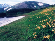
Alpine Plants
A remarkable feature of the Tsugami Shindou Geosite is its gradually changing climate. From the warm-temperate zone along the coast, to subarctic climates in the mountains, a variety of different climate zones can be found here. With these changes in altitude and climate come a variety of different forms of plantlife. Different alpine plants can be found in the various highland meadows and wetlands. Due to heavy snowfall in the region, many alpine plants are even found here at altitudes much lower than they would normally thrive.
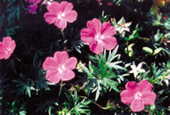
Arctic irises, Aleutian avens, and Asian skunk cabbage are only a few of the alpine plants which flourish on these mountains. During the flowering season, these meadows become a paradise of color.
Fossils
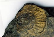
The fossils around this geosite are primarily from the Jurassic era, including ammonite, for which Mt. Kikusekiyama is named. Kikuseki means "chrysanthemum stone" and is another name for ammonite fossils. In addition to mollusks, the area contains a large number of plant fossils. Although yet to have been confirmed, the north side of Mt. Shiratoriyama is believed to house dinosaur fossils in its deeper strata.
Tsugami Mountain Retreat

In the center of the Tsugami Shindou Trail, just below the peak of Mt. Inugadake, the Tsugami Mountain Retreat offers shelter and rest for hikers along the trail. It was built by the Sawagani Mountaineering Club in 1968 and has since been expanded so that it can now accommodate up to 50 people.
The view from here to the Sea of Japan is unforgettable. On clear nights, the distant sea is lit by dozens of tiny lights from fishing boats.