- Yakeyama Hot Springs - Seifūkan
- Sasakura Hot Springs - Ryū'unsō

Road & Geosite Conditions
Partially Accessible

- Number
- Area
- 1. Ichiburi Geosite
- 2. Oyashirazu Geosite
- 3. Omi Coast Geosite
- 4. Omigawa Jade Gorge Geosite
- 5. Imai Geosite
- 6. Itoigawa-Shizuoka Tectonic Line and Salt Trail(North) Geosite
- 7. Maikomidaira Geosite
- 8. Hashidate Gold Mine Geosite
- 9. Kotakigawa Jade Gorge Geosite
- 10. Tsugami Shindo Geosite
- 11. Himekawa Gorge Via Oito Line Geosite
- 12. Itoigawa-Shizuoka Tectonic Line and Salt Trail(South) Geosite
- 13. Himekawa Gorge Geosite
- 14. Renge Geosite
- 15. Itoigawa Coast Geosite
- 16. Miyama Park and Museums Geosite
- 17. Tsukimizunoike Geosite
- 18. Umidani Gorge Geosite
- 19. Amakazariyama Geosite
- 20. Yakeyama Geosite
- 21. Benten-iwa Geosite
- 22. Shindosan Geosite
- 23. Gongendake Geosite
- 24. Tsutsuishi Hamatokuai Geosite
- Jade
- 1. Ichiburi Geosite
- 2. Oyashirazu Geosite
- 3. Omi Coast Geosite
- 4. Omigawa Jade Gorge Geosite
- 9. Kotakigawa Jade Gorge Geosite
- 15. Itoigawa Coast Geosite
- 16. Miyama Park and Museums Geosite
- Fossa Magna
- 5. Imai Geosite
- Itoigawa-Shizuoka Tectonic Line and Salt Trail(North) Geosite
- 11. Himekawa Gorge Via Oito Line Geosite
- 12. Itoigawa-Shizuoka Tectonic Line and Salt Trail(South) Geosite
- 13. Himekawa Gorge Geosite
- 17. Tsukimizunoike Geosite
- 21. Benten-iwa Geosite
- 22. Shindosan Geosite
- 24. Tsutsuishi Hamatokuai Geosite
- Mountainous areas
- 7. Maikomidaira Geosite
- 8. Hashidate Gold Mine Geosite
- 10. Tsugami Shindo
- 14. Renge Geosite
- 18. Umidani Gorge Geosite
- 19. Amakazariyama Geosite
- 20. Yakeyama Geosite
- 23. Gongendake Geosite
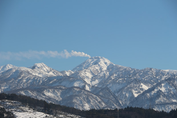
Mt. Yakeyama is a young active volcano at the northernmost tip of Fossa Magna born only some 3,000 years ago. The body of the mountain is a lava dome formed in 1361, during Japan's Muromachi period. It is still astir with fumarolic activity. Like Mt. Fugendake at Unzen in Kyushu, Mt. Yakeyama has erupted several times in the past, sending pyroclastic flow and ash into the valley below. According to geological surveys, the mountain has particularly violent eruptions about every 400 years, with eruptions during the Heian and Muromachi periods sending pyroclastic flow down over 20km to the coastline.
Nakagawara Terrace, formed as a result of pyroclastic flow during the Heian period (1200 years agoth) eruption, proved unsuitable for rice cultivation—the drainage was too good. During the Edo period, this area underwent extensive development to improve water retention and is now covered with beautiful and productive rice fields. Here within the verdant Joshin'etsu Kogen National Park you can see pyroclastic deposits, hardened lava flows, the remnants of beech forests buried by volcanic eruptions, and the mudstone that forms the foundation of Mt. Yakeyama. This mudstone has traditionally been used to make the inkstones used in Japanese calligraphy. In addition, you can see many dikes and other facilities built to protect against erosion, avalanches, and pyroclastic flow. With the threat of catastrophic eruption and the dangers of steam vents, life under a volcano is certainly dangerous, but not without its blessings—before leaving this geosite, be sure to relax in one of the hot springs here, the volcano's gifts to us all.

 About Climbing Mt. Yakeyama
The road to Mt. Yakeyama's climbing trail is closed due to land restoration and afforestation projects underway in the region. However, the road is open to tourists and hikers on Saturdays, Sundays and public holidays.
Mt. Yakeyama is a very active volcano. While current monitoring systems have not detected any increase of magma flow, recent increases in volcanic activity and steam production have forced the local government to prohibit access to the region within 1 km of Mt. Yakeyama's peak. If you plan to hike the Yakeyama region, please be aware of this restriction.
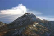
 Mt. Yakeyama
Mt. Yakeyama is on the mountainous border between Itoigawa City and Myoko City. It has an elevation of 2,400 meters, but only the top 400 meters of it are volcanic in origin.
It is an active volcano, but it has not had a lava or pyroclastic flow eruption since 1773. It has had several steam eruptions and continues to produce steam from its peak even today.
On 27 July 1974, Mt. Yakeyama had its most recent violent eruption, a large steam explosion that scattered volcanic debris in a wide area around the peak. 3 students from the University of Chiba who were conducting a survey of the local plantlife lost their lives during this eruption. Access to the mountain was prohibited from that point until 2006.
In the Summer of 2015, observation equipment began to detect increased steam production from Mt. Yakeyama. While there is no reason to believe an eruption is imminent, access to the peak has been restricted due to safety concerns.
|
|
|
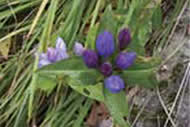
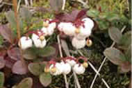
| Mt. Yakeyama | Alpine Plants | Alpine Plants |
 Erosion Control Dam
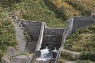
Hiuchiyamagawa River
Erosion Control Dam #1
In order to prepare for Mt. Yakeyama’s next eruption, the Japan Meteorological Agency and the Prefecture of Niigata have installed seismometers and cameras to continuously observe Mt. Yakeyama. A number of control dams have also been installed along the Hiuchiyamagawa and Yakeyamagawa Rivers. These dams can stop or slow volcanic landslides and mudslides, but they are powerless to stop lava or pyroclastic flow.
 Carbonized Trees at Kamihayakawa Elementary
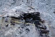
Carbonized Tree
A carbonized tree is one that has been instantly turned into carbon by pyroclastic flow. In a major eruption event, a superheated mixture of volcanic gases and dust called pyroclastic flow sweeps through the valley, scorching everything in its past. It is so hot that trees are instantly turned into charcoal.
During renovation of Kamihayakawa Elementary School's playground and track field, a large number of carbonized trees were uncovered. These trees once covered the valley in a forest until they were completely carbonized and buried by an eruption 1000 years ago.
While this eruption was undoubtedly extremely destructive, it created the gentle terrace seen today, perfect for rice farming.
 Standing Beech Trees
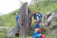
Beech Tree
At first glance these beech trunks standing in the riverbed may not seem like much, but they are actually evidence of Mt. Yakeyama’s birth 3,000 years ago! They were part of a beech forest that covered the valley until it was destroyed during the eruption that gave birth to Mt. Yakeyama.
Nunakawa Inkstone
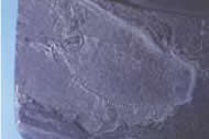
Nunakawa Inkstone
with fish fossil
The mudstone in this region was once known as "Nunakawa Suzuri." Suzuri are the inkstones used to prepare the inks used in Japanese calligraphy and Nunakawa Suzuri was highly valued for its quality.
Fossils of fish and other marine life can sometimes be seen in this mudstone, evidence that the entire region was once at the bottom of the sea.
Route to Yakeyama Geosite
Departure:
Destination:
Destination:
Mode of Travel: